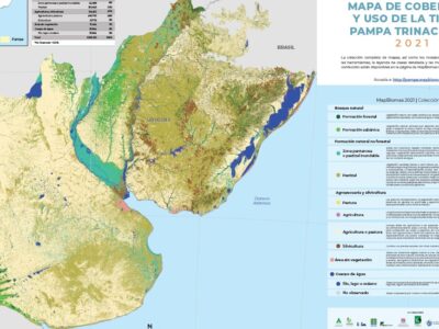
All MapBiomas products are constantly evolving. It is divided in Collections:

Collection 1 – published in May 2021 with a legend of  8 classes and covering the period 2000-2019.

Collection 2 – published in December 2022 with a legend of 8 classes and covering the period 1985-2021.

Collection 3 – published in November 2023 with a legend of 8 classes and covering the period 1985-2022.

WARNING:

MapBiomas Collection maps are an evolving product. When using the data make sure that you are always using the latest version available. MapBiomas maps have their best application in scales up to 1: 100,000. Although it is possible to view them on a 1: 50,000 scale, we do not recommend using them on this scale.

PRODUCTS AVAILABLE FOR THE GENERAL PUBLIC

  • Land use and land cover maps: maps in the matrix format (30x30m pixel). The legend of these maps, as well as the covered period, evolve throughout the collections.
  • Statistics of Land Cover and Land Use Change: data on land cover and land use for each class of the map for all Biome, each country, department, and municipalities/sub-regions. Also available the data on land-use change for several pairs of years for all classes.
  • Satellite images mosaics of each year of the time series, with a spatial resolution of 30m. The mosaics are formed by the composition of pixels in each set of images for a certain time period (e.g. filtering the clouds). The periods of the year in which the images are selected vary by country and result from the balance between the probability of maximizing the differences in classes spectral behavior and the availability of cloud-free images. In Uruguay and Brazil, the considered period was from September to November of each year while in Argentina from May to July. Time Periods were extended for some years and portions of the study area when the availability of cloud-free images was low. Each mosaic contains 107 layers of information including spectral bands, fractions, and indices (e.g. NDFI, NDVI, etc.). Mosaics can be accessed directly in Google Earth Engine for processing or download.
  • Web platform for public consultation with images, maps and statistics of the MapBiomas Pampa Trinacional Collection.

PRODUCTS AVAILABLE FOR SPECIALISTS OR DEVELOPERS

  • Methodological notes explain the whole working method including the specificities of each class.
  • Access and Download Tools on Google Earth Engine – allows you to access and download MapBiomas data for different territorial sections.