• About Mapbiomas
    • Project
    • Products
    • ABOUT US
    • Team
    • Other Initiatives
    • Terms of use
  • Map & data
    • Access the platform
    • Statistics
    • Downloads
    • Accuracy analysis
    • Terms of use
  • Methodology
    • METHODOLOGY OVERVIEW
    • ATBD - STEP BY STEP
    • Tools
    • Glossary
    • Terms of use
  • FAQ
  • Communication
    • LAUNCHES
    • News
    • MapBiomas Articles
    • Videos
    • Terms of use
  • Contact
es en pt-BR
Log in
Access platform Forum Log out

Downloads

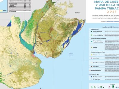
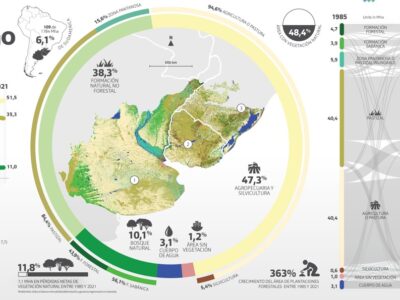
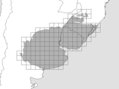
Here you can download maps, statistical data and access the Landsat image mosaics from the MapBiomas Collections.

Collection Maps

Pampa annual maps of LULC of MapBiomas Trinational Pampa.

Statistics

MapBiomas Pampa Trinacional map statistics database in Collection 2.

Landsat Mosaics

Landsat satellite image mosaics since 1985.

Legend Code

File with the codes of the legend classes that appear in the raster files of the MapBiomas collections.

Mural map

Detailed maps of land cover and land use of Pampa South American biome in 2021.

Reference Map

References from various organizations used in the classification.

Infographics

Graphic materials with data on the evolution of land cover and use in Pampa South American biome between 1985 and 2021.

Fact Sheet

Main information on land cover and use in the Pampa Sudamericana region.

Provided by

Powered by

© 2019 MapBiomas

Development